
The sponsored tours and activities at the Goethe Institute this week were varied and intense.
First, an architectural tour led us outside the city, and to Mexicoplatz, where precedents to Early Modern and Bauhaus styles were still visible. Dr. Carola Veit, who also led two previous architecturally-oriented tours (Potsdamer Platz and the Street Art in Kreuzberg), was our guide. Known as Zehlendorf, this area became a wealthy residential community when Germany’s nouveau riche industrialists built large country houses in the area. Streets and areas were named after cities or countries in South America.
Muthesius studied philosophy and traveled extensively in Asia and Europe. A country house by Muthesius borrowed from the English style that combined garden with building. Designed for entertaining clients, the house included a large dining area, a music room, a separate room for women to drink tea after dinner, and one for men to play cards and smoke. A large catering kitchen was separated from the house to reduce smell and accommodate deliveries. The family’s quarter were located on the floor above the rooms used for guests. (see photo collection below, upper right)
This was one of the first houses developed in Germany utilizing the concept of “form follows function”. Very little external decoration was used as a departure from previously built homes. Many of the former houses borrowed from many styles and were eclectic in nature. As the industrial class emerged and artists became more prominent, the new design approach respected and encouraged more radical new ideas in architecture. He was also involved in the design of Hellerau, a garden city outside Dresden. You can read more about Muthesius in https://en.wikipedia.org/wiki/Hermann_Muthesius and my posting on Hellerau from August 2013.
The project in a forested setting shown in the photo at the lower left was developed between 1926-1932 and was known as “Uncle Tom’s Cabin”. In the 20’s after the first World War, families were very poor and suffered from lack of housing. Bruno Taut attempted to develop decent multi-family housing for families with social and drug problems. Rooms were small, but units had bathrooms, kitchen, and good natural light. The garden was in the back of the development away from the street. All ground floor units had access to the garden, and upper units had individual balconies. Bright “parrot” colors were applied on exterior facades. (see photo below, lower right)
Bruno Taut and his younger brother Max collaborated on projects together and were among the first of the early Modern architects in Berlin. They also married sisters! He went to Moscow in 1932, lived in Japan for awhile, then emigrated to Turkey where he died in 1938.


Two houses nearby were developed by Mies van der Rohe. (Photos above, upper left and bottom left). A wealthy family hired Mies to build a Prussian style house. Mies struggled with the client’s request, but was able to finesse the design by expanding the windows. In his second house, he made a stronger connection between the outer garden and the interior space. In addition to creating large windows, he added an exhibition space for the client’s art collection and reduced the floor to floor height. Today, the complex is a school for handicapped children.

The next evening, I attended a lecture that covered German History after World War II. I can’t say that I understood everything in German, but the handouts summarized three periods: from 1945-1948; 1949-1958; and 1961-1972. In the first phase after the war, the international powers divided and dominated geographic areas of Germany and Berlin. In the second phase, the Stalin and the Soviets controlled East Germany and East Berlin; and in the last phase the Khruschov-Kennedy era, the Warsaw Pact led to the building of the Berlin Wall.
One of the more interesting graphics from the lecture showed wagon trains of Germans evacuating Poland and Baltic States after the war.
The very next morning we were offered a follow-up tour of the lecture. “On the Tracks of the National Socialists”, we made stops at the Holocaust Memorial, the site of Hitler’s bunker, and a huge government building built in the 60’s. It was a perfect way to bring perspective on the previous night’s facts.
Standing at the Brandenburg Gate, our guide introduced the development of the Nationalist movement. Albrecht Speer, the Chief Architect and Art Minister for the Nazis, had visions for a new German state. Designated as Germania, this massive new complex in Berlin would become the center of the world. A palace bigger than Versailles was planned there just next to the Brandenburg Gate. 180,000 people could fit inside the building for events.
This massive scheme was never built. Because Berlin was so heavily bombed, many of the new buildings were not built until after reunification in the 90’s. Some buildings look older because they duplicated the original buildings.

The Holocaust Memorial shown above was designed in 1980s by Peter Eisenman, an American architect. The exterior memorial is abstract in honoring the 6 Million Jews who died. Below the memorial, there are four rooms in the museum: one is empty for reflection; the second one is dedicated to the history of the Jewish people; the third one has names of each person who died with his or her biography; and fourth one has a map of places where Jews were deported. The museum serves as an important resource and research center.
Nearby, we stood over a parking lot where Hitler lived his last days in a bunker below. The movie “Marriage of Eva Braun” depicted the grim experience. He had married his secretary only a month before. Goebbels and his family were also in this bunker. Determined to have his children die as Nazis, he gave them cyanide pills before he and his wife killed themselves.
Because Hitler burned to death in the bunker after he committed suicide, no remains were found. Even his teeth were apparently missing. Our guide gave us a few thoughts on the Hitler’s whereabouts. There were a number of conspiracy theories. One was that he fled to Argentina. Another theory was that the Russians, who operated a major center in Magdeburg, took his remains there or buried them in the river. Of course neither theory has been proven.
The history of Berlin is very complicated. In order to help me navigate around the city and understand the physical location of the Berlin Wall, I purchased a postcard of the borderline between East and West. At a granular scale, it is very confusing and intriguing, what parts were where.
You can see that the wall circles around Mitte, the heart of the city. I live just at the edge of the line identified as Number 2 on the postcard. Bernauer Street is where a park is located to commemorate the wall. Communities and neighborhoods that were divided by the wall show a noticeable difference in the architecture, quality, and development stage. Large tracts of land are either left abandoned, waiting for development, or they have already been developed. It really keeps one guessing what happened and curious about both the history and the future.
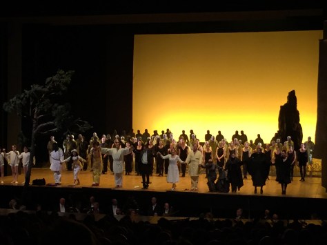
And if the past few days didn’t have enough activity, here’s one for the opera lovers: the curtain call for the Magic Flute at the Deutsche Oper, another Goethe Institute sponsored event.
(In Banner above: Topography of Terror, a display about the Stasi. See https://en.wikipedia.org/wiki/Topography_of_Terror)
(Note: Apologies for the length and delay of this post. There may be a few factual errors that are being checked for accuracy).
Post updated: 6/7/16

Fascinating!
LikeLike
Where are you?
LikeLike
Vic, tom whiting from S.H. and SF. Super blog! I ll be using it to guide my partner and I through germany in a months time. Keep writing. Tom
LikeLike
Hi Tom
It’s great to hear from our GI class members from Schwabisch Hall 2015! I hope you will enjoy the activities galore here in Berlin when you come. Take advantage of the many small venues that happen in neighborhood churches!
LikeLike